|
The
Divided
Neck
Could
the Book of Mormon's “narrow neck of land” be separate from the feature described as “a small
neck of land” and called “the narrow pass” or “the narrow passage”? A
few scripturally plausible interpretations (Divided Neck hypotheses) are
presented in this article. Phyllis Olive’s current model, which
consolidates
“the narrow pass” with
“the narrow neck” into a single, small isthmus,
remains the most unified interpretation; but certain
Divided Neck ideas are worth considering. One of these may turn out
to be most correct!
Scripture states:
“And they built a great city by the narrow neck of
land, by the place where the sea divides the land.”
(Ether 10:20)
Instead of referring to
“that great sea which divideth
the lands [plural]”
(Ether 2:13),
the verse above refers to a
“narrow neck of land” in an American
setting, and a “place where
the sea divides the land
[singular]”.
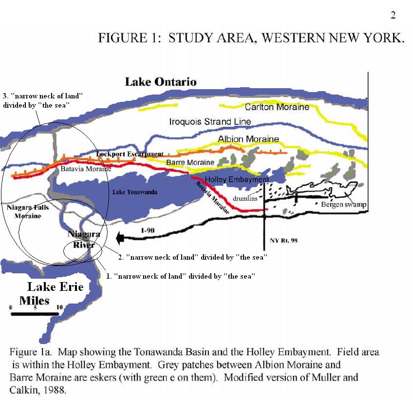
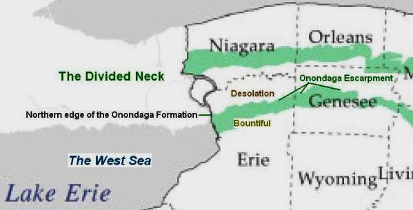
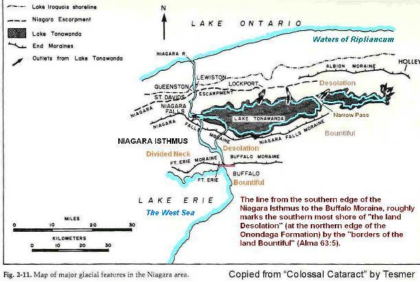
Circled in the map above are three interpretations of a “narrow neck of
land” divided by “the sea”.
In each case
“the land” divided by “the sea”
is interpreted to include “the narrow neck”.
In hypothesis 3, “the sea” is
interpreted to be
Lake Erie + Niagara
River + Lake
Tonawanda.
The feature described in scripture as “a
small neck
of land”, called “the
narrow pass”, having waters of a "sea" (singular)
“on the west and on the east” of it
(Alma 50:34) is
interpreted to be the
Batavia Moraine.
Batavia is a Dutch place name meaning
“good land surrounded by, or near water”.
Notice that the
Batavia Moraine also appears on
the Ontario side of the
Niagara Isthmus, running more or less parallel with
the isthmus. So “the
narrow pass” (or rather the linear mound of the
Batavia Moraine) is to some extent
found within
"the narrow neck" (considering the whole Niagara Isthmus to be "the narrow neck
of land" - proposal 3). In other words, though the geological
feature giving rise to "the narrow pass" is
separate and distinct from the Niagara Isthmus, in a sense, the moraine becomes
one with the isthmus!
It’s a geological fact that the Batavia Moraine passed through ancient Lake Tonawanda,
dividing the inland sea into an unobstructed, effluent western part,
and a more stagnant eastern end. As depicted in the map above (adapted from
Heidi Natel’s master’s thesis in geology), Lake Tonawanda can be viewed as an arm, or extension of Lake Erie. This doesn't necessarily mean that ancient
peoples of the area referred to both lakes using the same name. The waters of Lake
Tonawanda were also fed by
Tonawanda River - now a creek.
“Tonawanda”
is a Native American
name
meaning
“confluent stream” or
“swift water”.
Given the scriptural location of the Book of Mormon land Cumorah
(LDS
Doctrine and Covenants 128:20,
Mormon 6:4)
in relation to the nearby land Zarahemla
(Mosiah 8:7-8;
21:25-26), Lake Erie is
the most likely candidate for the Book of Mormon’s “west sea”
- bordering the lands of Bountiful, Zarahemla and Nephi.
(Alma 22:27-33;
50:11,
52:11-12,
Helaman 4:5-8)
In Phyllis Olive’s straight forward model, the Book of Mormon’s
“small neck of land”, “narrow neck”, “narrow pass”, “narrow passage” all
relate to a single geological feature – the Batavia Moraine.
Olive has considered various geological
facts, and numerous literary setting scenarios. Olive’s model
(featuring
Lake
Tonawanda and the Batavia
Moraine) remains the most unified interpretation. Even so, seeing the
“narrow neck”
and
“narrow pass”
as two
different things,
resolves and simplifies other aspects of the Book of Mormon American setting.
Occam's razor
has something to say about preferring the simpler explanation. It is left to the reader to decide which interpretation fits scripture best
.
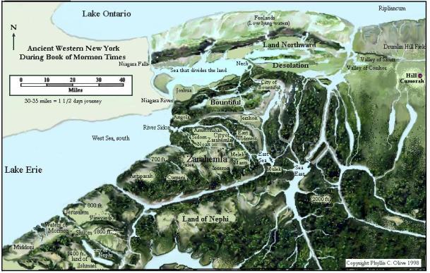
Olive's remarkably accurate depiction of the Book of Mormon's
authentic literary setting near Cumorah. The map tacitly favors a
Consolidated Neck model. The land of Desolation is labeled on the
east of a small neck of land (the Batavia Moraine), but extends west to the
Niagara as "the land" (singular) divided by "the sea" (Lake Tonawanda) -
Olive's interpretation of Ether 10:20.
The biggest challenge to Olive’s Consolidated Neck model is a verse in Alma 63 which reads:
5
And it came to pass that Hagoth … built him an exceedingly
large ship, on the borders of the land Bountiful, by the land Desolation, and
launched it forth into the west sea, by the narrow
neck which led into the
land northward.
Combine the above verse with the only other reference in the Book of Mormon
that explicitly names “the narrow neck”
(Ether 10:20-21):
20
And they built a great city by the narrow neck of
land, by the place where the sea divides the
land.
21
And they did preserve the land southward for a wilderness, to get game.
And the whole face of the land northward was covered with
inhabitants.
Unlike “the narrow pass” or “passage”,
“the narrow neck of land” was not a
continuous isthmus, or so it can be interpreted. The “narrow neck of land” was divided by “the sea”, “the west sea”
(or an extension of it). Notice in the passage of scripture about Hagoth
(Alma 63:5),
that “narrow neck” is mentioned, whereas Moroni, in abridging the ancient Jaredite record, makes the effort to engrave
“narrow neck of land”.
(Ether 10:20)
This becomes important when considering that “the narrow neck of land, by
the place where the sea divides the land” clarifies which land [singular] is
meant by “the place where the sea divides the land”. The narrow neck itself
was divided by the sea.
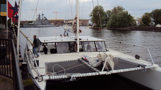
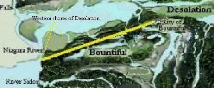
A large shallow draft catamaran in the mouth of the
Book of Mormon's
"river Sidon" (Buffalo River), on the southwest borders of "the land Bountiful"
(at Buffalo NY), a little south of the Niagara Isthmus.
In the Divided Neck scenario, Hagoth launched an “exceedingly large
ship” directly into
Lake Erie near the divided Niagara Isthmus. The
western side of the divided isthmus (across “the west sea” from Hagoth’s launch site) was that part of “the narrow neck which
led into the land northward” (Ontario, Canada in this
case).
The "land northward" of
Helaman 3:8,
with Lake Ontario as "the sea east" (meaning sea on the east). The
Hebrew word designating "east" connotes "sunrise". The western part of
the Niagara Isthmus (lower right) leads into "the land northward".
(Alma 63:5)
Scripture doesn't say that "the narrow neck"
led into the land southward. It was "the narrow pass"
(the Batavia Moraine) that
connected northern and southern lands on what is now U.S. soil.
(Alma 50:34;
52:9,
Mormon 2:29;
3:5)
It’s crucial to understand that the Book of Mormon
expressions, “land northward”, and “land southward” are not the names of
particular lands, as, for instance the name of the land “called
Desolation”, or the land “called
Bountiful”.
(Alma 22:30-31)
The expressions “land northward”, and “land southward” are relative. These expressions give the
directions to lands based on frames of reference.
The expression
“land northward”, or “land southward” mean the same as “land on the
northward”, or “land on the southward”, respectively.
In the reference frame of
Alma 22:31 the
land “called Bountiful” is referred to as “the land on the southward”. In the reference frame of
Helaman 4:5-8,
however, “the land southward” refers to land south of Bountiful. Consider also
3 Nephi 3:23-24;
6:2.
Likewise, the expression
“sea east” is not the name of a particular body of water.
(Helaman 3:8) Nor was there a sea called
the west sea, south.
Scripture explains that the expression,
“on the west sea, south ...” simply means
“in the borders of
the land on the south by the west sea.”
(Alma 53:8,
22)
The sea referred to was called “the west sea”.
That was the
Nephite name for the body of water, even when viewed as
“the sea south” (sea on the
south) relative to places in Ontario Canada.
As you come upon relative expressions in scripture like
“sea
north”
and
“land north”
(Helaman 6:10)
ask yourself -
“north”
etc.
with respect to what? And then try to identify the reference frame in
scripture.
The elevated Jaredite seat of power at “Moron”
near the land “called
Desolation by the Nephites”, was built on prophetic
ground that would later be associated with a singular “nation” - the United States of America
– “free from … all other nations under heaven”.
(Ether 2:9-12;
7:5-6,
17;
14:11)
In
Alma chapter 22, “the land on the northward …
called Desolation” featuring a “small neck of land between the land
northward” and the more elevated “land southward”,
(Alma 22:30-33)
fits the NY, Lake Ontario coastal flatland, and the Tonawanda
basin – all on United State
soil. The fertile country to the south is elevated just as scripture
describes.
(Alma 22:31)
Olive has chosen to make the generalization that the passable “small
neck of land” (Batavia Moraine) is one and the same as the “narrow neck”
mentioned in other verses, including the verse about Hagoth’s great
ship (raft, catamaran, shallow draft sailing vessel).
The scriptural term “curious” describing Hagoth, relates to the
biblical Hebrew
מַחֲשָׁבָה,
fromחשׁב
.
The Hebrew
implies clever, well thought out, contrived, highly
skilled. (See
Exodus 35:32,
1 Nephi 18:1,
Helaman 6:11) The
translated adjective “curious” therefore has more to do with describing
Hagoth as an engineer than an explorer. Hagoth stayed ashore and “built
other ships.” There is no scriptural account of Hagoth going on a
voyage – ill fated or otherwise.
(Alma 63:4-9)
As for the account of the lost passengers, it is possible they sailed from Lake Erie
“northward” into Lake Huron, or after arriving in “the land northward”
embarked into Lake Ontario and “were never heard of more.”
Hagoth's ships were not launched into the Pacific Ocean. Any real connection between Book of Mormon peoples, and peoples of
the Pacific Islands, must involve distant migrations from
North America, and intermarriage with islanders. It is entirely possible that Pacific
Islanders long ago navigated to American shores, and there
interacted with local peoples, including descendents of immigrants from
temperate North America.
While it’s true that the description “exceedingly large ship” is relative, Hagoth’s
motive for building the huge craft was probably to acquire “onties”
(Nephite monetary weight in silver, i.e. Alma 11:25).
He wanted to establish a large shipping business. To that end, his “exceeding large
ship” was likely optimized and much larger than even a tree long Jaredite barge; which,
according to scripture, was regarded as “small”.
(Ether 2:16-17)
The fact that Hagoth’s great ship took its
“course
northward”
doesn't necessarily mean it sailed due north, right away, without a course change. The
Hagoth verses (Alma 63:5-6)
allow for the possibility that after Hagoth
“launched” his
“exceedingly
large ship ... into the west sea”, it
could have sailed southward along the Erie coast
picking up
“much provisions”
and
“many” passengers, before they
“took their course northward” (perhaps northwest).
Hagoth could have built several great vessels
that sailed out into Lake Erie.
A ship launched into “the west sea”, could have entered the mouth of
Canada’s
Grand River, and from there sailed
"northward" into Ontario
Canada
and back.
From the Erie coast, by
the divided isthmus, some of Hagoth’s “other ships” (if not
the large
forerunner) could have sailed expeditiously into the Niagara strait
to the shores of Desolation. In this case, returning to Lake
Erie, might require
towrope and poles -
if sail and oar were not enough to overcome the current in the shallows. Lighter craft could
of course, be transported overland back to Lake Erie. This
is yet another possible route
Hagoth’s ships could have sailed in the authentic Book of Mormon
setting - near Niagara’s isthmus.
We might ask, how the Nephites would have described the divided isthmus?
Would they have called it a “neck of land”? It seams reasonable that they
would have. They could have at least viewed parts of the isthmus at a time.
In the mind’s
eye, based
on their explorations, they could have perceived the whole isthmus as a
“neck of land”. A
crucial question remains: If Niagara’s “neck of land” is not “small”
like “the narrow passage” near Batavia (Bountiful), is there any scriptural
justification for describing some sizeable part, or all of the divided isthmus as
“narrow”? There is:
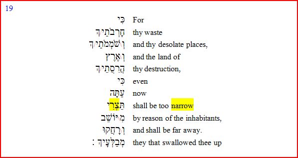
19
For thy waste and thy desolate
places, and the land of thy destruction, shall even now be too narrow by
reason of the inhabitants; and they that swallowed thee up shall be far away
[Heb. thy devourers shall be distant] . (1 Nephi 21:19, Isaiah 49:19, KJV)
The word
צר
translated “narrow” can mean “cramped”, “tight” or “strait”. In the passage
above, “narrow” applies to the
coastal
land of Judah
after the exile. This covenant land is some miles in breadth and length.
Thus the word “narrow” may also
appropriately describe a once crowded desolate land in America – a “narrow neck of land” –
“narrow” by reason of the former inhabitants.
(Helaman 3:5-6)
In
short, there
could be a reason for the different names: “the narrow pass” and “the narrow
neck”.
The Hebrew word translated "passage"
(1 Samuel 13:23) can also be translated
ford
or pass. (The New Brown-Driver-Briggs-Gesenius Hebrew-Aramaic
Lexicon, 4569,
מעבר,
pg. 721) But the Hebrew word for "neck" is an
entirely different word. So are we dealing with two different names for the
same thing, or two different things?
The
feature described as “a small neck of land” was named
“the
narrow pass”.
(Alma 22:32;
50:34,
see Helpful Notes:
Truth Table) This
feature with the waters of a “sea” (singular) “on the west and on the east”
of it, was not a continental isthmus that took more than a day to walk
across, but was so localized and guarded that scripture describes it as a
“point”
(Alma 52:9);
this in contrast to the breadth of Bountiful which is
described as a “line”.
(Alma 22:32-33,
3 Nephi 3:23)
Olive
convincingly associates the
“pass”
that spanned the inland sea, with the Batavia Moraine. What a find she has
made! While the moraine certainly fits the description of a soggy but
passable narrow neck, it’s possible that the geographic feature
named
“the narrow neck of land” was part of, or all of the divided Niagara Isthmus.
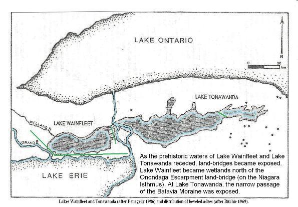
Isthmuses exposed by the
receding waters of
Wainfleet Bog
(west) and Lake Tonawanda (east).
Adapted from a map by archaeologist
William Ritchie, and provided by author
Phyllis Olive.
The term
“narrow pass” doesn't appear in the abridged Jaredite record
- at all!
The Jaredite account predates the Nephite record with its multiple mentions
of
“the narrow pass”. What appears
in Moroni’s
abridgement of the more ancient account, is
a reference to a great city
“by the
narrow neck of land, by the place
where the sea divides the land”!
(Ether 10:20)
The level of Lake Tonawanda was
higher during the archaic times of the Jaredites. This raises a question: Was the Batavia Moraine
swamped during much of this period? If so, during the poisonous serpent pestilence, was the
way to the south in the vicinity of Bountiful? In other words, were Jaredites
near the southern shore of Lake Tonawanda, the ones hedged in by the serpents, so
that they “could not pass”
by the way
“towards the land southward, which was called by the Nephites Zarahemla”?
(Ether 9:31-34;
10:19)
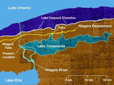
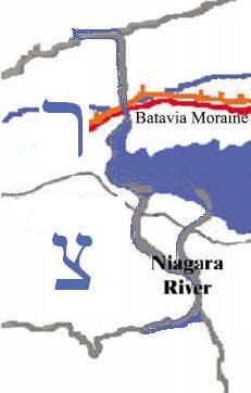
Prehistoric Lake Tonawanda may date back to ~12,000 years BP.
As Lake Erie receded, the exposed Batavia Moraine parted Lake Tonawanda
into western and eastern portions.
It makes
sense that Hagoth would have launched craft at Lake Erie by the divided
Niagara Isthmus, and also at Lake Tonawanda, perhaps even in the shallow
waters near the Batavia Moraine. Both bodies of water are
interconnected. It's likely, however, that the Nephites had a separate name for
“the sea” that "the narrow
pass" traversed.
(Alma 50:34)
Olive’s
Consolidated Neck model requires that Lake
Tonawanda go by the name “the west sea” to satisfy the Hagoth account. (Alma 63:5)
Indeed, there was water to the west of
the Batavia Moraine, near Olive’s proposed launch site, but
there was also a part of Lake Tonawanda on the east. It
seems more appropriate that the Nephites would have named Lake Tonawanda
the north sea, consistent with how they named other bodies of
water
in relation to their principal lands. Better yet, the Nephites could have named the northern
lake the Desolation sea! Scripture only says that there was a
“sea ... on the west and on the east” of “the narrow
pass”.
(Alma 50:34)
Scripture does not tell us the name of “the sea” by “the narrow
pass”. The name of the sea by “the narrow neck”,
on the other hand, was definitely “the west sea”.
(Alma 63:5)
Scripture says that it was
“the sea” that divided
“the land”.
(Ether 10:20) The
wide Niagara River was seen as “the
sea” dividing the land. The
Hebrew word for “sea” can apply to a “mighty river”. Though Lake Tonawanda
(as an arm of “the west sea”) took part in dividing “the land”, there is no
indication in scripture that
Lake
Tonawanda was actually
called the sea that divides the land, distinguishing it in that way
from “the west sea” (Lake Erie).
This begs a question: In light of three earlier references to
“the narrow
pass” (including the one describing it as
“a small neck of land”;
Alma 22:32;
50:34;
52:9),
if
“the narrow neck”
(Alma 63:5)
is not the same as
“the narrow
pass”, why would the Nephite account suddenly mention
“the narrow neck”
without any distinguishing introduction? Was the different name
combined with the mention of
“the west sea” thought sufficient to distinguish
“the narrow neck”
from the previously mentioned
“narrow
pass”? Perhaps the answer is that simple!
According to Olive’s model, there are borders
of Bountiful by Desolation
near the Batavia Moraine, and also near portions of the
divided Niagara Isthmus (westward). But near “the west sea” (Lake Erie), the southern borders of Bountiful at Sidon (Buffalo River) are much closer to Desolation than anywhere else. Hagoth could have built his
“exceedingly large ship” as far south as “the borders of the land Bountiful”,
near the mouth of Sidon; and still have been
“by the land Desolation” (a short distance northward).
(Alma 63:5)
Today, ships routinely launch out into Lake Erie at this location - despite the
currents near Niagara River.
“...on the line Bountiful and
the land Desolation ...” -
“...the line which was between
the land Bountiful and the land Desolation”, running nearly parallel to the
Onondaga Limestone Escarpment.
(Alma 22:32-33,
3 Nephi 3:23)
The southwest borders of Desolation should logically correspond to
the Onondaga Lime Stone Escarpment intersecting the eastern Niagara coast. But what if
the edge of the formation was obscured or missing due to erosion or removal? How could the Nephites
have defined
“...the borders of the land Bountiful, by
the land Desolation” at this locale without excavating for limestone?
(Alma 63:5)
What if large amounts of Onondaga limestone were removed in this region of Nephite
shipping; for the purpose of
making cement?
See Helaman 3:10-11.
There is an alternate way of determining the southwest borders of
“the land Desolation”
near “the place where the sea divides the land” - based on the
closest, southern edge of the Niagara Isthmus.
(Alma 63:5,
Ether 10:20)
In Summary:
Hagoth’s “exceedingly
large ship” was built, not on the nether shores of Desolation, but on the borders of the
forested land Bountiful. Why is “the narrow neck of land which led into the land northward”, not mentioned
in Alma 63:5 until after the launch of Hagoth’s
ship into “the west sea”? Is it because the narrow neck was
actually parted by water? (Ether 10:20)
The part which “led into the land northward” would therefore be across the water, in sight of the ship when it was launched.
Both the Batavia Moraine and the
Niagara Isthmus can reasonably be described as a “neck”.
Scriptural justification has been shown for calling a small coastal land
(measuring some miles in length and breadth), “narrow”.
See also Joshua 17:15.
Part, or all of the Niagara Isthmus may qualify as
scripturally “narrow”.
The
entire Niagara Isthmus certainly does not qualify as a
“ narrow
pass”. It also does not have waters
of a
“sea ... on the west and on the east” of it.
(Alma 50:34)
The Batavia Moraine fits perfectly that description. Also, unlike
“the narrow
pass” (Batavia Moraine), the divided Niagara Isthmus
does not lead into land southward of the Onondaga Escarpment - because it is divided by an inland sea, or mighty river. Scripture says that
“the narrow
neck .. led into the land northward”.
(Alma 63:5)
It was
“the narrow
pass which led into the land southward” and “... into the land northward”.
(Mormon 3:5,
Alma 52:9)
In the
annals of Nephite history the maiden voyage of vessels launched at either
Lake Erie or Lake Tonawanda may have been described using somewhat similar
sounding geographic
references, i.e. the borders of the lands Bountiful and Desolation, the full accounts of which got abridged:
14
But behold, a hundredth part of the
proceedings of this people, yea, the account of … their shipping and their
building of ships … cannot be contained in this work. (Helaman 3:14)
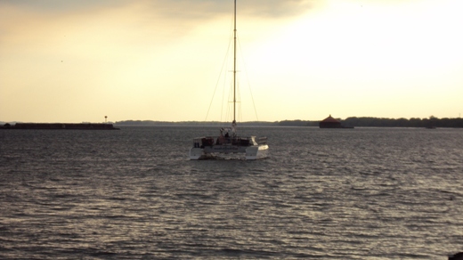
A large, shallow draft catamaran launching out into the Book of
Mormon's "west sea" (Lake Erie) by the Niagara Isthmus.
HELPFUL NOTES:
Narrow Neck versus Narrow Pass
Truth Table
|
Scriptural, Geographic Constraints:
|
“narrow neck“:
|
“narrow pass”:
|
|
By “the west sea”.
|
Yes,
Alma 63:5
|
|
|
Associated with “the place where the sea divides the land.”
|
Yes,
Ether 10:20
|
|
|
Only known to lead “into the land northward.”
|
Yes,
Alma 63:5
|
|
|
Connects both “land northward” and “land southward”.
|
|
Yes,
Alma 50:34;
52:9,
Mormon 2:29;
3:5
|
|
By an unnamed body of water referred to as a “sea”.
|
|
Yes,
Alma 50:34,
Mormon 3:5-8
|
|
Waters of the unnamed “sea, on the west and on the east” of it.
|
|
Yes,
Alma 50:34
|
|
Small enough in width to be described as a geographic “point”.
|
|
Yes,
Alma 52:9
|
Note:
The
description “a small neck of land between the land northward
[Desolation in
this case] and the land southward [Bountiful etc. in this case]”
(Alma 22:32)
best describes the Batavia Moraine or “narrow
pass”. The
“narrow
pass” situates on prophetic
U.S.
soil.
(Ether 2:7-12;
7:6)
The description
of “the narrow pass”
does not appropriately describe the lateral and divided Niagara Isthmus or “narrow neck of land …
where the sea divides the land”.
(Ether 10:20)
The Book of Mormon “narrow
pass” as it exists today, a little north of the Onondaga Escarpment,
near
Batavia, NY (Bountiful). In
order for Hagoth to construct a great ship “on the borders of the land
Bountiful” near this location, and to launch it into Lake Tonawanda,
the great vessel would have to be transported down the escarpment into Desolation’s
sea below. If on the other hand, the Book of Mormon “narrow
pass” is different than the “narrow neck”, in that the “narrow neck”
is part of, or all of the conspicuous Niagara Isthmus, then the “exceedingly large” vessel could
be launched from Bountiful’s
western shore directly into “the west sea, by
the narrow neck ...”
(Alma 63:5)
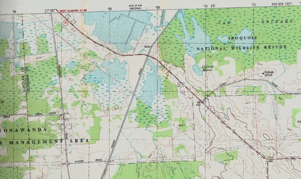
An enlarged portion of an 1804 map of western NY. Tonawanda
Creek (represented in the map) flows northward over the Onondaga Escarpment
at
“Indian Falls”
into the basin that once held Lake Tonawanda. Note the pass (between the
13s) with wetlands
on the west and on the east of it. Even in
Joseph Smith’s
days the Batavia
Moraine was used as a pass through the marshy remnants of ancient Lake
Tonawanda.
“ ... by the narrow pass which led by the sea
into the land northward, yea, by the sea, on the west and on the east.”
(Alma 50:34)
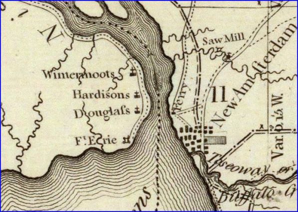
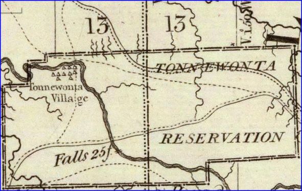
An enlarged portion of an 1804 map of western NY
showing the site of New Amsterdam (later Buffalo) built across from a
neck-like extension of the Niagara Isthmus, near the place where Lake Erie
first divides the isthmus as Niagara River.
“And they built a great city by the narrow neck of
land, by the place where the sea divides the land.”
(Ether 10:20)
Hebrew source for KJV Isaiah 49:19
(1 Nephi 21:19)
The Hebrew word “narrow” (צר)
spelled out by the Niagara River. The Hebrew spelling has other appropriate
meanings.
(Esther 7:6)
Does GOD have a sense of humor or what?
You may also want to read
W. W. Phelps'
LAND OF DESOLATION
and
Why Lake Erie, and not Lake Tonawanda, is the Western Terminus of the Land Bountiful
Vincent Coon
וִינְסֶנט כּוּן
כּ
© Copyright 2015
|