|
Why
Lake Erie,
and not
Lake Tonawanda,
is the Western Terminus of the Land Bountiful
Reason 1
– Lake Tonawanda
was in the Book of Mormon land Desolation. This ancient inland sea
was near Bountiful,
but did not form a shore of that land.
Scripture
states:
31
And they came from there [Desolation]
up into the south
wilderness.
Thus the land on the northward was called
Desolation, and the land on the southward was called Bountiful ...
(Alma
22:31)
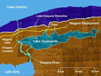
The Onondaga Limestone Formation and escarpment
parallels the linear divide or “line which ran between the land
Bountiful
and the land Desolation.” (3
Nephi 3:23) Desolation is north of the escarpment, and at lower
elevation than Bountiful. Bountiful resides on, and immediately south of the
escarpment.
 ; ;
Desolation on the north, and Bountiful
“up” on the south of the linear escarpment.
(Alma 22:31)
Unlike the fortified
“line” of Bountiful
on the south (Helaman
4:6-7), there is no mention of the “line” between Desolation and
Bountiful being fortified in early
Nephite times. (Alma
22:32) There is mention of a
“sea” north of
Bountiful, in the land Desolation
(Lake Tonawanda,
e.g.
Mormon 3:7-8,
Alma 50:34). But the sea on the west of Bountiful (west of all
inhabited Bountiful) is clearly the one named
“the west sea” (Alma
22:33). The northern end
of
Bountiful extends inland from the west sea, “only
a day and a half’s journey” (Alma
22:32).
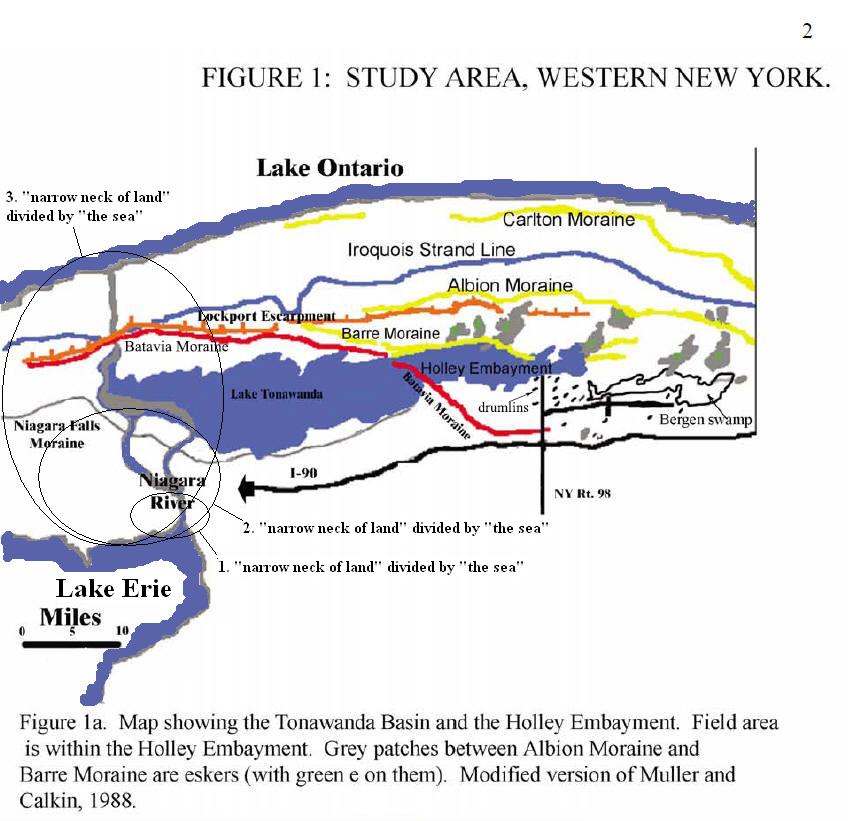
In her
2004 master’s thesis,
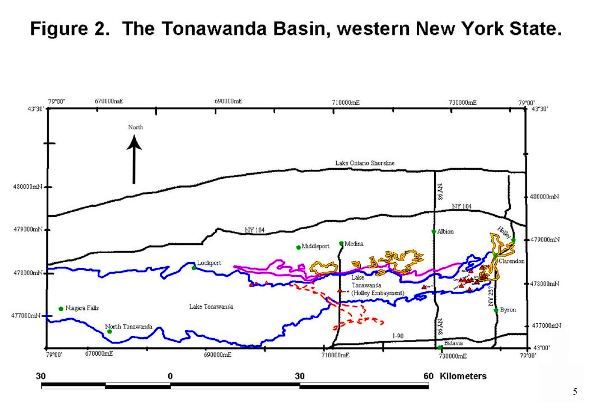
geologist Heidi Natel explains that the “Tonawanda Basin lies between
the (Middle) Devonian Onondaga Escarpment and the (Middle) Silurian Lockport
Escarpment to the north (Figure 1.).”
(pg. 12)
As the
waters of ancient Lake Tonawanda receded, the Batavia
Moraine became exposed as
“a small
neck of land”
(Alma
22:32) called
“the narrow pass”.
(Alma
50:34)
From Hebrew,
“the narrow pass”
can also be translated
“the narrow passage”.
(Mormon
2:29; see
The New Brown-Driver-Briggs-Gesenius
Hebrew-Aramaic Lexicon, entry 4569,
מעבר, pg.
721)
The
“narrow pass”
passed through Desolation’s sea - “between the land northward and the land
southward”.
With the
Batavia Moraine
exposed as the “narrow pass
which led by the sea
into the land
northward, yea, by the sea,
on the west and on the east.” (Alma
50:34), the receded
waters of Lake Tonawanda
formed shorelines some distance north of the Onondaga Escarpment. In other
words, the lake’s ancient shoreline in
Nephite times was down in the land of Desolation. In
fact, western
Lake Tonawanda became
bounded north of the Niagara Falls Moraine (Figure 1.) which is north of the
Onondaga Escarpment (the natural boundary between the
land
of Desolation and the land of Bountiful). The
Onondaga Lime Stone Escarpment is a little
north of, and approximately parallel to I-90, shown in Figure 1 above.
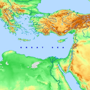
Figure
א. This map shows
the
authentic Book of Mormon setting featuring “the west sea” (Lake
Erie), and the natural linear boundary between the lands of Desolation and Bountiful.
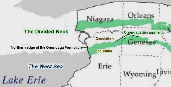
Figure
ב.
The southern portion of the diagonal Batavia Moraine (tan) sits on the
Onondaga Limestone Formation (light tan). From the Onondaga Formation, the
Batavia Moraine extends northward, down into the
land
of Desolation, and then
runs more or less parallel with, and within the divided
Niagara Neck - as
depicted in Figure 1.
Tonawanda Creek
is nearby, spilling
over the Onondaga Escarpment at
Indian Falls,
just west of where the
Batavia Moraine
passed through the ancient inland sea.
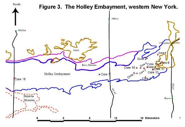
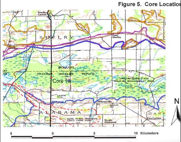
Natel: Figures 2, 3 and 5
depict the
Batavia Moraine and
Prehistoric Lake Tonawanda’s shoreline
(undiminished) – north of the Onondaga Limestone Escarpment.
Natel’s mollusk macrofossil study indicates that as
Lake
Tonawanda
receded, and the exposed
Batavia Moraine
cut off the
eastern waters of the lake
from the more
effluent western side,
different aquatic species came to inhabit the more
stagnant eastern end.
(E.g. pg. 72, Figure 23.)
This is proof positive that in later stages of the lake, there really and
truly was a small neck of land that passed through, and divided the inland
sea. Early 19th century maps of western NY, in fact, show that the moraine
was used as a pass through the muck-lands.
One
or more prominent 19th Century antiquarians speculated that the
marshlands of Western NY were diminished remnants of what was once much
larger waters.
(Josiah Priest,
American Antiquities and
Discoveries in the West, 1833 edition, pg. 352)
Prehistoric Lake Tonawanda may date back to ~12,000 years BP.
As the waters receded, the exposed Batavia Moraine divided Lake Tonawanda
into western and eastern portions. Curiously, the expression “narrow pass”
does not appear explicitly in the abridged Book of Ether, record of the
archaic Jaredites. If the moraine was not entirely inundated in
Jaredite times, it may have been soggy, constricted, and at times
impassable. During the dearth mentioned in
Ether 9:30-31, the isthmus may have been completely exposed but rendered
impassable due to “poisonous serpents”.
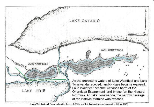
Isthmuses exposed by the receding
waters of
Wainfleet Bog
(west) and Lake Tonawanda (east).
Adapted from a map by archaeologist
William Ritchie, and provided by author Phyllis Olive.
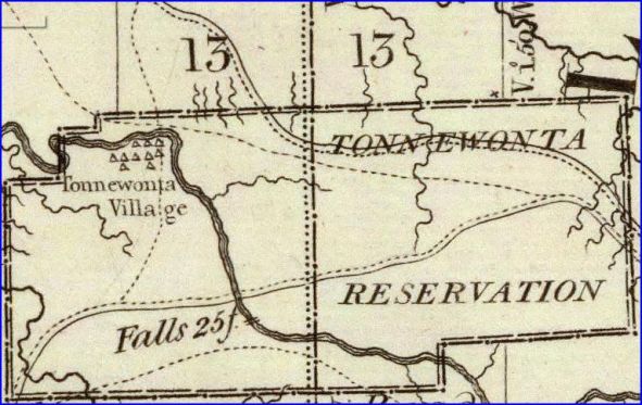
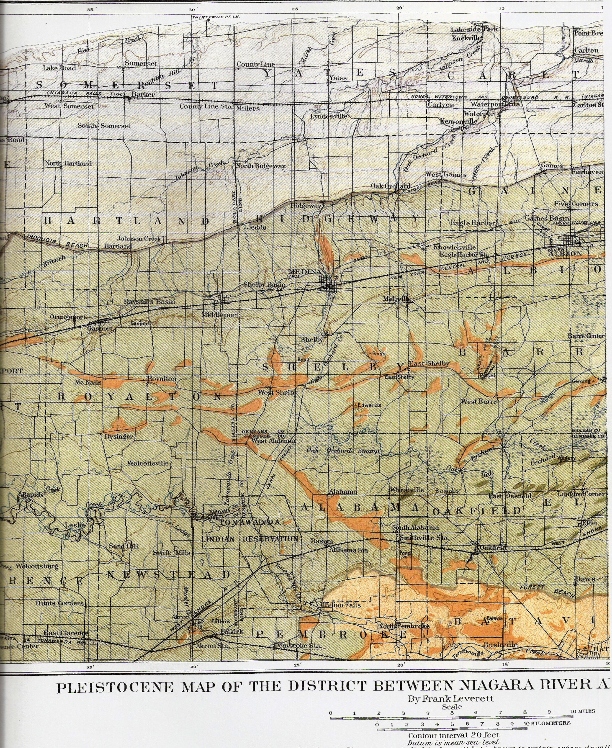
An enlarged portion of an 1804 map of western NY. Tonawanda
Creek (represented in the map) flows northward over the Onondaga Escarpment
at
“Indian Falls”
into the basin of what once held Lake Tonawanda. Note the pass
(between the
13s) with wetlands on the west and on the east of
it. Even in
Joseph Smith’s
days the Batavia Moraine was used as a pass through the marshy
remnants of ancient Lake Tonawanda. The first colonial reference to Indian
Falls near the Batavia Moraine, comes from an 1804 account of the
destruction of scores of rattlesnakes near the falls. Apparently the local
natives referred to Indian Falls as “The
Place of Snakes”. This calls to mind the plague of “poisonous serpents”
described in
Ether 9:31-34.
“ ... by the narrow pass which led by
the sea [singular]
into the land northward, yea, by the sea, on the west and on the east.”
(Alma
50:34)
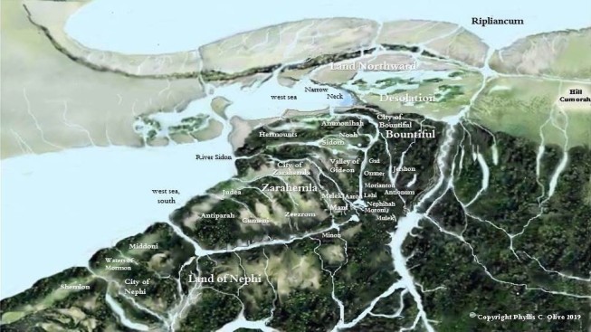
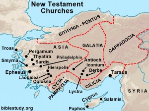
A Revised Book of Mormon Geography Map
according to
Phyllis Olive’s latest
model.
Lake Erie
– the Book of Mormon “west sea”:
Reason 2 – Lake Tonawanda was not west (towards sunset) with respect to all who inhabited Bountiful.
Scripture states:
33
And it came to pass that the Nephites had inhabited the land Bountiful, even from the east unto the west sea …
(Alma
22:33)
Scripture does not say “the Nephites inhabited … the land Bountiful … from the east
almost to
the west sea…” or that “the Nephites inhabited … the land Bountiful … from the east unto the
nearly west-northwest
sea…”
Proximal to the land Cumorah (LDS
Doctrine and Covenants 128:20), Lake
Erie matches the Book of Mormon “west sea” splendidly.
The Great
Lake’s extent meets the requirements of
scripture, and provides an analogue to the great western sea of the land of
Israel, which is also an inland sea.
An inhabitant of the land Bountiful, and not just on the northern line,
could travel west, and place one foot in “the west sea” while keeping the
other foot planted on Bountiful’s western shore. Also, as explained, the
borders of the land Bountiful
(which reside “up” above the Onondaga Formation) did not extend to the
receded edge of Lake
Tonawanda. The diminished inland sea could not have been Bountiful’s western terminus. Bountiful came short of
Lake Tonawanda. Lake Tonawanda
was “the sea” that invaded nether Desolation. (Mormon
3:5-8) Lake Tonawanda (both parts) was simply among the “large
bodies of water” found in “the land northward”. (Alma
50:29;
33-34)
The Bountiful “west sea” is in all likelihood the same “west
sea” that forms the western coasts of Zarahemla and the more southern land of Nephi. (Alma
50:11;
52:11-12;
53:8,
22)
On Phyllis Olive’s revised Book of Mormon geography map (above),
Lake Tonawanda (both parts) is clearly seen situated in what Phyllis labels
the “Land Northward”. Here Phyllis treats the Book of Mormon
expression “land northward” as if it were the name of a specific land, and
not a relative designation that could be applied to any land northward from
an arbitrary reference frame. In Alma
50:11 the reference frame is the dividing line “between the land of Zarahemla and the land of Nephi”. From this reference frame, Zarahemla is in “the land northward”. From more northern reference frames, Zarahemla is “the land southward”.
(Ether 9:31,
Omni 1:22) One wonders why the same reference frame would
not have been used to describe ancient Lake Tonawanda, as was used to describe the land
that held the two-part lake. Why not refer to Lake Tonawanda as the sea
northward?
In the reference frame of
Alma 22:31 the
land Bountiful is referred to as “the land on the southward”. In the reference frame of
Helaman 4:5-8,
however, “the land southward” refers to land south of Bountiful. The “land southward” in this case includes Zarahemla. Consider also
3 Nephi 3:23-24;
6:2.
Bountiful’s fortified southern line “... a day’s journey”, probably ran along a western part of Buffalo River, and then along part of
its tributary, Cayuga
Creek. This fortified line ran “from the west sea even unto
the east”. (Helaman
4:7) The eastern terminus of the fortified line was likely
the beaches of a lake or inland sea in the vicinity of what is now Tonawanda
Creek.
(Bulletin of the Geological Society of America, Vol. 10, Tonawanda
Valley, 32-34)
Near the mouth of Buffalo River (Book of Mormon river Sidon) the southern borders of the forested land of Bountiful were a short distance
south
from Desolation. Near this location, a ship could be built, and set sail
into Lake Erie without being overpowered by the
Niagara currents. (Alma
63:5-7)
The point is, the western terminus of the southern Bountiful line is also “the west
sea”. The west sea, at the southwest edge of Bountiful, cannot possibly be
Lake Tonawanda. Lake Tonawanda was north of Bountiful.
(Alma 50:11,
29,
34)
Sister Olive’s reshuffling
of the land Bountiful on her current map (above), does not justify naming Lake Tonawanda the “west
sea” relative to Bountiful. Lake Tonawanda was “on the west and on the east” with respect to “the narrow pass”, within “the borders of the land Desolation” near Bountiful. (Alma 50:34)
Notwithstanding Olive’s best attempt to buttress a
consolidated neck hypothesis, the Book of Mormon does not say that “the sea” that “the narrow
pass” traversed, was called the west sea. Scripture says that it
was “the narrow neck” that was by “the west sea”. (Alma
63:5) Why should we suppose that “the narrow pass”
and “the narrow neck of land” are different things?
Scripture tells us that in the
vicinity of “the narrow neck of land” there is a “place where the sea
divides the land”. The
archaic Jaredites “built a great city” near there. (Ether
10:20) Thus, “the narrow neck” most likely has something to do
with the conspicuous Niagara Isthmus. Great Lake Erie clearly “divides the
land” at the place where Lake Erie becomes the
Niagara River. See Figure 1a, Figure
א,
and other maps above. With Buffalo River close by to the south, this makes
an ideal location for a
“great city” - in fact, there is
one there today!
Recall that in Figure 1, a portion of the
Batavia Moraine actually passes within the Niagara Isthmus. The word
isthmus, by the way, means narrow neck. (OED) So in
a way, “the narrow pass” (or rather the Batavia Moraine) and the divided
Niagara Isthmus become one.
If, as Phyllis Olive has
suggested, the site of the great Jaredite city mentioned in
Ether 10:20 was near “the narrow pass” (the Batavia Moraine), the verse might more appropriately read, “And
they built a great city by the narrow
passage, by the place where the
small neck of land divides the
sea.”
Sister Olive has argued that Lake Tonawanda is the land dividing sea
referred to in
Ether 10:20. This ancient inland sea divided the
land of Desolation.
But all lakes divide land. We should ask, what singular
spot on the shore of a lake qualifies as the place where it divides the
land?
The description, “... a great city by the narrow neck of land, by the place
where the sea divides the land”, seems to call out an address. The
address consists of a pair of coordinates, or pieces of information: The
first piece of information is “... by the narrow neck of land...” This could
mean across from, or in sight of an isthmus. Secondly, the verse seems
to call out a place where the sea divides land (singular), perhaps
even dividing “the narrow neck of land” itself. If “the place where the sea
divides the land” refers to where Great lake Erie first cuts into “the
narrow neck of land” as a mighty river, or
strait, this would be enough information to locate the great
Jaredite city where Buffalo NY resides today. Buffalo is across from the Niagara
Isthmus. Buffalo is also by the place where Great Lake Erie becomes the
swift Niagara River cutting through the
isthmus - the neck.
A soapstone pipe from Spiro Mound, Oklahoma (13th-century CE),
showing a warrior beheading his victim.
(Thomas S. Garlinghouse,
“Revisiting The Mound-Builder Controversy”) Consider
1 Nephi 4:10-18, and the analogy of two necks of land (isthmuses)
named in the covenant land setting of the Book of Mormon: (1) a
small neck of land, named the narrow pass, that divides a sea, and
(2) a narrow neck of land
that is divided by a sea. Both are near “the
line Bountiful and the land Desolation” (Alma
22:32-33), but at opposite ends. One isthmus is found near the
eastern start of the line, and the other is at the western end. The covenant
land symbolism in this case may be compared to the symbolism of
Mount Gerizim versus
Mount Ebal in the
biblical Promised Land setting. (Deuteronomy
11:26-29;
27:11-13;
Devarim 11:29,
Joshua 8:30-34) In the American Promised Land, the narrow pass
may be seen to symbolize the blessing upon the land. (Alma
46:17-18) That the LORD prospers and protects the way of the
righteous, as he did their fathers; making a path for them in the midst of
the waters -
cutting a covenant with them analogues to the narrow pass
dividing the sea. The narrow neck
on the other hand may be seen to symbolize the curse upon the wicked who
inhabit the land. (3
Nephi 3:23-24) Should the people persist in wickedness, the God
of the land will cut them off, as he has the western isthmus, part of which
leads into a “land northward”. (2
Nephi 4:4,
Alma 9:13;
45:15-16;
50:20-22)
Unlike “the narrow pass”, there is no indication in scripture that
“the narrow neck” was a continuous, undivided isthmus that “led into the land
southward”. (Mormon
2:29;
3:5,
Alma 63:5) See Narrow Neck versus Narrow Pass Truth Table at the end of this article.
West of the Niagara River
divide, “the narrow neck ... led into the land northward.” It was “by the
narrow neck” that Hagoth launched his “exceedingly large ship … into the
west sea”. (Alma
63:5) The mouth of Buffalo River (at the southwestern borders of
Bountiful) can accommodate very large ships. It is an ideal location for a
Nephite,
Sidon-like seaport. There
are two battleships and a submarine moored there today. A short distance
north of this location is the divided Niagara Isthmus, with the
Onondaga Limestone Escarpment forming the southern edge of the isthmus.
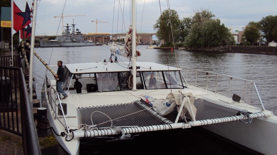
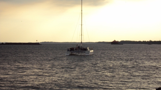
A large catamaran launches out into the "west sea" (Lake Erie)
from the mouth of "Sidon"
(Buffalo River), by the divided Niagara Isthmus - seen in the distance.
(Alma
63:5)
The region of the city of Zarahemla was regarded by the Nephites as
“the heart of their lands”, “the center”, or “most capital parts” of their
lands. It stands to reason that the names of nearby inland seas would
coordinate with the Nephite “center” or “heart”. (Alma
60:19)
From “the heart of their lands”, the names “east sea” and “west
sea” make sense. Similarly “east sea” (the Salt
Sea,
Ezekiel 47:18,
Joel 2:20,
Zechariah 14:8,
ZekharYah 14:8,
Numbers 34:2-3) and “utmost sea”
(the Mediterranean,
Devarim 34:2,
Yo'El 2:20) are
appropriately named relative to Jerusalem. The Hebrew words, “ha-yam ha-aharon”
translated
“the utmost sea” in the
KJV,
can actually be translated “the
western sea” - west from Jerusalem and the land of Israel in general.
Relative to the Nephite “center”, Lake Tonawanda
was just one of a number of “large bodies of water” in the north. (Alma
50:29) This is one of the reasons why “the waters of Ripliancum”
(Lake
Iroquois) north of the land Cumorah and the hill Ramah, are described as
“large, or to exceed all”. (Ether
15:8-11) The waters of Ripliancum were larger than all the Finger
Lakes and Lake Tonawanda, and yet
Book of Mormon peoples must have understood that there was land
northward beyond Ripliancum.
Reason 3
– Even though Lake Tonawanda was connected to Lake Erie, it is unlikely
that Lake Tonawanda (north of Zarahemla) would have
been called “the west sea”.
The fact that the ancient inland sea is identified today by the
name “Lake Tonawanda”, not Prehistoric Lake Erie, should prompt us to
consider that even though the lake was contributed to by Lake Erie (via
the Niagara River, as was ancient
Lake Iroquois for that matter), it most likely would have been given its
own name in former times. Names like north sea, or better yet,
Desolation sea would have been appropriate, and consistent with how
neighboring bodies of water were named relative to the Nephite “center of
the land”. Besides, it’s difficult to determine how diminished Lake
Tonawanda was by
Nephite times. That is, it’s difficult to say for certain how connected
Lake Tonawanda was to Lake Erie near Tonawanda’s shallower end.
Tonawanda River
(near “the narrow pass”) could have been a significant contributor to the
shallow Lake in
Nephite times. The Nephites must have had means of fording
Tonawanda
River to get to
“the narrow pass”. Its possible that part of the palisade fortified city of Bountiful spanned
both sides of a portion of the river, so that the city under siege would not be cut off from its water supply. (Alma 53:3-4)
Today there is a small bridge spanning Tonawanda Creek in the town of
Batavia.
Of course, the extreme eastern end of Lake Tonawanda was not
connected to Lake Erie at all, and yet the Nephites seemed to have
identified both the western and eastern parts of this inland sea as a single
body of water divided by a small, pass-like moraine. The Nephites seemed to
have regarded the two parts of Lake Tonawanda as the same “sea” (singular) -
one part on the west, and one part on the east.
You will recall that scripture states that “the narrow pass .. led by the sea [singular,
not
seas] into the land northward, yea, by the sea, on the west and on the
east.” (Alma
50:34)
If it was the shallower end of Lake Tonawanda, just west of the narrow pass,
that Hagoth launched his exceedingly large ship into, according to Olive’s interpretation of
Alma 63:5, then why doesn't the scripture read, “... launched it
forth into the
sea west by the
narrow pass ...”, instead of naming the sea and reading, “... launched it
forth into the west sea by the narrow neck ...”?
Olive’s Lake Tonawanda launch site requires building the
“exceedingly large ship on the borders of the land Bountiful”, above Lake
Tonawanda, and then somehow getting the large vessel downhill into the shallows of
Desolation’s inland sea.
It makes sense that the Nephites would have distinguished Lake Tonawanda
with some name other than “the west sea” in order to avoid ambiguity with
Great Lake Erie
that formed the long, western coast of their principal lands?
Indeed, the simplest, most straightforward interpretation of
scripture supports the conclusion that “the west sea”, on the western coast
of Nephi and Zarahemla, is the same “west sea” that forms the western coast
of the land Bountiful. This great body of water
is consistently named “the west sea” throughout the Book of Mormon.
The land Bountiful “north” of the Nephite “center of
the land”, plainly shares Lake Erie’s coast with the lands of Zarahemla and Nephi.
The scriptural statement “... land southward which was called by
the Nephites Zarahemla” is consistent with a point of view based in Bountiful or Desolation. Zarahemla is
“southward” from Desolation and
Bountiful. (Ether
9:31,
Omni 1:22)
But no large body of water in the land northward (which land was named
Desolation by the Nephites) is explicitly named the west sea in the
Book of Mormon. (Alma
50:29;
33-34) You will recall that the land below Indian Falls (The
Place of Snakes) is Desolation. The land above Indian Falls is
Bountiful. At the time of a great famine, man and beast wanted to escape serpent infested lands by fleeing southward.
(Ether
9:30-35)
What about the expression “west sea, south”, that occurs once in
scripture? (Alma
53:8) Does this expression represent a different, or more
specialized name for Lake Erie - distinguishing it from Lake Tonawanda? In
other words, can the expression “on the west sea, south” be construed to
suggest that Lake Tonawanda was called “the west sea”, and Lake Erie “the
west sea, south”?
Why wouldn't the Nephites have kept the title “the west sea”
exclusively for the great western sea (analogues to
the Western Sea of the land of Israel) and referred to Lake
Tonawanda as the west sea, north? The short answer is, the Nephites
did refer to Lake Erie as the “the west sea”. We don't know the name they
gave Lake Tonawanda.
The same Book of Mormon chapter restates the meaning of the
expression
“…on the west sea, south”. The Book of Mormon explains that the
expression means, “on the south by the west sea.” (Alma
53:22) Nothing more is suggested. The Book of Mormon name of Great
Lake Erie is “the west sea”, but depending on where you are, you may be
talking about a coast of the “the west sea” that is south of you.
Similar expressions are found in Hebrew scripture. Keep in mind there is no
capitalization in Hebrew, and commas were not used anciently: See for
example
Numbers 34:3,
Bemidbar 34:3 in Torah. Here the Hebrew expression “yam ha-melah qedemah” is
translated “the salt sea eastward” (KJV). The scripture is not saying
that the name of the Old World sea is “salt sea eastward”. The name of the
sea is simply “yam ha-melah”; translated in English (with its
reversed syntax) “the salt sea”, or “the Salt Sea” (if you wish to capitalize it and
show that it is a name). The added expression, “eastward”, is just a
relative direction based on a frame of reference given in scripture - that's
all. The same is true for
Bemidbar 34:11. The name of the sea is “yam kineret” (Sea of
Galilee), not “Sea of Galilee East”. Likewise the name of the Mediterranean
Sea in
Joshua 23:4,
Yehoshua 23:4 is “the Great Sea”, not “the great sea westward”.
The Book of Mormon follows word constructions that are similar to
those that appear in the Bible.
Here is how the name east sea or East Sea (if you whish to
capitalize it) appears in Hebrew scripture:
הים
הקדמוני
I have put the
definite articles in
blue
so you can better understand the construct. Transliterated into English, the
Hebrew name is pronounced:
“ha -yam
ha-qadmoni”
It literally means
the
sea
the
east (eastern), but it is translated “the east sea” (e.g.
Ezekiel 47:18,
YehezqEl 47:18,
Joel 2:20,
Yo'El 2:20).
Similarly, the
west sea or West Sea appears in Hebrew scripture as
ה ים
האחרון
Transliterated, and then directly translated this
becomes
“ha-yam
ha-aharon” =
the sea the
west (western), but it can be interpreted to mean “the west sea” or “the
Western Sea”
(Devarim 34:2,
Yo'El 2:20).
Now, contrast the above with how the terms “sea east” and “sea west” are
expressed in Hebrew:
ים קדמה
This transliterates and then translates as “yam qed'mah” = “sea east
(eastward)”. This relative designation is not a name. It tells the direction
to a sea from some reference frame.
Similarly, sea west in Hebrew may be written:
ים מבוא השמש
This expression may be transliterated and then translated as “yam
mevo
ha-shemesh” = sea
setting of the sun (west, westward) = “sea west”. This is also not a
name of a body of water. It's a relative designation telling us where the sea
is with respect to a reference frame that is subject to change.
The name, or proper noun “west sea” has the construct “west”
(adjective) + “sea” (noun), whereas “sea west” or “sea south” is a noun
(sea) followed by a direction (e.g.
Helaman 3:8). Even if a
definite article is placed in front of the noun, for instance, “sea” ( ים) is replaced with “the
sea” (הים),
“the
sea west” that results still doesn't qualify as the name of the sea. The Book of Mormon
expression “the sea west” is just another way of saying “the sea … on the
west” (Alma
22:27), or “the sea that is west”.
The expression “west sea, south” is a proper noun (West Sea)
followed by an adverb - a direction (south). The expression “west sea,
south” (Alma
53:8) is a way of referring to a southern coast of “the west
sea”, relative in this case, to the Nephite center in the land Zarahemla. (Alma
53:22)
The Book of Mormon name of the body of water, we now call
Lake Erie, is “the west sea”. This is consistently the case throughout the
Book of Mormon, even when this inland sea, Lake Erie, is not mentioned by name,
but referred to as “the sea south” (relative to a frame of reference in what
is now Ontario, Canada,
Helaman
3:8). The situation is analogues to describing the biblical
“Western Sea”, also called “the Great Sea”, from a reference frame in Asia Minor. From Tarsus,
for instance, Israel’s west sea
could properly be referred to as “the sea south” or sea on the south.
The biblical “west sea”
(named in the covenant land of Israel) is “the sea south” relative to Tarsus in Asia Minor.
The Nephites also had a way of saying southeast, or
southwest. See
1 Nephi 16:13. If, for some strange reason, they had wanted to
distinguish Lake Erie by naming it the southwest sea, they would
not have used words that translate “west sea, south”.
Relative to her relocated
Bountiful, Lake Tonawanda in Phyllis Olive’s revised Book of Mormon geography, is better described as a
sea on the
north-northwest.
“the east sea”
From the King James Translation alone, the attentive
Bible reader can tell that ancient Israelites referred to lakes
as seas. The word lake is found nowhere in the KJV Old
Testament. Even relatively small, inland bodies of water were
called seas.
There are many inland seas (lakes) east of
Lake Erie. In ancient times especially, the Finger Lakes region
was truly “a land of many waters, rivers, and fountains” - challenging for
an invading force to penetrate. (Mormon
6:4) Invading war parties might have to carry canoes across a region covered by rivers
and inland seas.
Publishing the views of naturalists of his day,
Josiah Priest
(a renowned contemporary of the Prophet Joseph Smith) stated that “the
western lakes … Erie, Seneca, Cayuga, and many lesser ones, are the mere
remnants of the great inland sea which once existed in this region”.
(Priest,
American Antiquities and Discoveries in the West, “FURTHER REMARKS ON
THE DRAINING OF THE WESTERN COUNTRY OF ITS ANCIENT LAKES”, 1833 edition, pg.
370)
Referring to the American Promised Land, Book of Mormon scripture
states that “after the waters had receded from off
the face of this land it became a choice land above all other lands,
a chosen land of the Lord…” (Ether
13:2) - a land akin
to Israel’s
Old World inheritance:
7
For the LORD thy God bringeth thee into a good land,
a land of brooks of water, of fountains and depths that spring out of
valleys and hills;
(Deuteronomy
8:7)
“How
great a lapse of time took place from the subsiding of the flood of Noah”,
till the bursting of barriers that held vast inland seas in America, Priest
is unwilling to speculate. (A.A.,
1833 edition, pg. 369) Suffice to say that Priest and others set
forth the view in Joseph Smith’s time, that “the millions of mankind, with
their multifarious works, covering the vales of all our rivers, many of
which were once the bottoms of immense lakes, and where the tops of the
tallest forests peer to the skies, or where the towering spires of many a
Christian temple makes glad the heart of civi'ized man, and where the
smoking chimnies of his widespread habitations - once sported the
lake serpent…”
(A.A.,
“DISAPPEARANCE OF MANY ANCIENT LAKES OF THE WEST, AND OF THE FORMATION OF
SEA COAL”, 1833 edition, pg. 352)
We
shouldn’t be surprised, therefore, to find that contemporaries of Joseph
Smith recognized in the marshes north of
Batavia
the remains of an ancient inland sea; that local rivers, creeks, and
wetlands had once been much larger bodies of water in ages past. Such an
understanding was not beyond 19th century New Yorkers. (LDS
Doctrine and Covenants 128:23)
The geological facts are, that in the vicinity of a
major
NY fault, near what is now Tonawanda Creek, there are remnant
beaches (Alma
51:32) of bygone lakes.
( Bulletin
of the Geological Society of America,
Vol. 10, Tonawanda Valley, 32-34)
Geologist
Frank Leverett, for instance, notes several
“beaches” of former lakes in western New York.
(Glacial Formations and Drainage Features of the
Erie and Ohio Basins, PL. III)
The Tonawanda Creek corridor running parallel to the Clarendon
Linden Fault is somewhat analogues to the
Jordan Rift Valley
of the biblical Promised Land. But unlike the Old World Jordan,
Tonawanda Creek flows northward. Long ago there was an inland sea or lake at
the head of Tonawanda Creek in the Beaver Meadow, Gallagher Swamp, and Java
Lake region.
(Leverett,
Glacial Formations and Drainage Features of the Erie and Ohio Basins,
pp. 210-213)
This lake also fed the narrow Cattaraugus Creek
corridor which like the torrent bed of the brook Qanah of the Bible,
runs westward to a great western sea (Lake Erie, analogue of the Mediterranean
Sea).
Further east, and south of the yawning Letchworth
Gorge, was ancient Lake Genesee.
(Leverett, Glacial
Formations and Drainage Features of the Erie and Ohio Basins, pp. 201,
204, 206, 649)
In as much as the meaning of the Semitic name Jordan (Yarden)
suggests a river, the dramatically descending
Genesee River becomes a likely candidate for the Nephite river “Jordan”. This
Nephite river is implied by the place-name mentioned in
Mormon 5:3. So there are actually two Nephite rivers named in the
localized American setting (one of them implied), and not just the
river Sidon.
The river Sidon is never mentioned flowing through the lands of Bountiful and Desolation to the large waters of Ripliancum
in the north. (Ether 15:8) Rather
Sidon flows out to sea like the biblical
river Kishon.
Compare Judges 5:21,
1 Kings 18:40 with
Alma 3:3;
44:22.
The Nephites were certainly familiar
with the Old World river ha-Yarden
(1
Nephi 10:9) and its appropriate meaning. In fact the Semitic
names Jared (Yered)
and
Jordan (Yarden)
come from the same root -
yarad. It is appropriate therefore that the Nephite river “Jordan” flows down and through the northern lands of the Jaredites (Yeredim) to the
large waters of Ripliancum (Lake
Iroquois, with its fenlands and inland arms). In fact, the sea east of the land of Nephi (ancient
Lake Genesee) could have been perceived by the Nephites as an analogue to “yam
kineret”, what Gentiles call “the Sea of Galilee”, or “Lake
of Gennesaret”. The Nephite river Jordan descended to and through
ancient Lake Genesee. Lake Genesee is depicted on Phyllis Olive’s map above.
Here we have possible candidates for east inland seas
in the
authentic Book of Mormon setting. But which of these best
fits the one the Book of Mormon calls “the east sea”?
The
covenant land setting of the Bible should here be considered as a
template for the
Book of Mormon setting:
There is more than one eastern sea in the small Biblical Promised Land. (Numbers
34:11-12,
Joshua 12:3;
13:27;
15:5,
12,
2 Chronicles 20:2) These bodies of water are connected. We should consider the
possibility that as the great western sea (the
Mediterranean) is much larger than the biblical eastern seas
(lakes), so the Book of Mormon “west sea” (Great Lake Erie) could be
considerably larger than the eastern seas (lakes) in the Book of Mormon
setting. (Numbers
34:6,
Joshua 1:4,
Ether 9:3)
Of the
interconnected eastern seas referred to in the Bible, one was
actually called “the east sea”.
(Ezekiel 47:18) The renowned inland sea is eastward with respect
to Jerusalem. More commonly called “the salt sea”
(or Dead Sea by Gentiles), this
famous lake situates in the southeastern quarter of the land. (Numbers
34:3,
Joel 2:20)
Was the Book of Mormon “east
sea” also located in the southeastern quarter of Nephite territory?
There was a wilderness corridor between the Book of Mormon
“east sea” and “the west sea”.
From scripture we conclude that “the narrow strip of wilderness”, the
“straight course” of the
land of Nephi,
which formed “the line between … the land
of Zarahemla and the land of Nephi”,
ran from “the east sea to the west [sea]”. That “west” means
“west sea” in
Alma 50:8, is clear from the following verses taken together:
27
And it came to pass that the king sent a proclamation
throughout all the land, amongst all his people who were in all his land,
who were in all the regions round about, which was bordering even to the
sea, on the east and on the west, and which was divided from the land of
Zarahemla by a narrow strip of wilderness, which ran from the sea east even
to the sea west, and round about on the borders of the seashore, and the
borders of the wilderness which was on the north by the land of Zarahemla,
through the borders of Manti, by the head of the river Sidon, running
from the east towards the west—and thus were the Lamanites and the Nephites
divided. (Alma
22:27)
8
And
the land of Nephi
did run in a straight course from the east sea to the west. (Alma
50:8)
11
And thus he cut off all the strongholds of the Lamanites
in the east wilderness, yea, and also on the west, fortifying the line
between the Nephites and the Lamanites, between the land of Zarahemla and
the land of Nephi, from the west sea, running by the head of the river Sidon—the
Nephites possessing all the land northward, yea, even all the land which was
northward of the land Bountiful, according to their pleasure.
(Alma
50:11)
Thus, “to the west” definitely means to “the west [sea]”
in
Alma 50:8.
It's useful to know that more than one Hebrew word is
translated
“west”. Because the western coasts of Israel's inheritances are “unto the great sea toward the going down of the sun” (Joshua
1:4), one of the Hebrew words that can be translated
“west” or “to the west”, literally means “seaward” or “to the sea”. For
example: “toward the west” in
2 Nephi 21:14
(Isaiah
11:14) is really the Hebrew word
יָמָה
pronounced “yamah”. This word literally
means “seaward” or “to the sea”.
Thus we see that when translated into
Hebrew,
Alma 50:8
need not contain an ellipsis (i.e. omission of the word “sea”)
after all. The Hebrew word translated “to the west” may literally mean “to
the sea”, suggesting to the Israelite mind “unto the great sea toward the
going down of the sun, shall be your coast”. (Joshua
1:4)
Hebrew terms that are translated “east” relate to facing or
standing before sunrise. Standing before an eastern body of water
is not implied. (2
Nephi 12:6;
21:14,
Isaiah 2:6;
11:14)
With these biblical facts in mind, we should be careful,
not to generalize the apparent ellipsis in
Alma 50:8, jumping to the conclusion that “from the east” means
from “the east [sea]” in
Alma 22:32-33:
32
And now, it was only the distance of a day and a
half's journey for a Nephite, on the line Bountiful and the land Desolation,
from the east to the west sea …
33
And it came to pass that the Nephites had
inhabited the land Bountiful, even from the east unto the west sea
...
(Alma
22:32-33)
The
“sea” (or lake) by the eastern borders of the land
Bountiful is never actually called the east sea.
(Alma
27:22) The Book of Mormon
seems to deliberately avoid naming the eastern terminus of Bountiful
“the east sea”, even when “the west sea” is mentioned
first as the western terminus, that is, in reverse order from
Alma 22:32-33. See
Helaman 4:6-7 - curious! Now contrast the
apparent avoidance of the name “east sea” in connection with the eastern
ends of
Bountiful’s southern and northern lines,
with the more southern “straight course” or “line ... between the land of
Zarahemla and the land of Nephi”: Here we find the seas named at both ends
in different verses, that is, “from the east sea” and “from the west sea”. (Alma
50:8,
11)
It may be significant that the word “east” in
Alma 22:32-33
is not capitalized in the Book of Mormon Printer’s Manuscript. The
printer or typesetter, on the other hand, apparently interpreted that
“east” meant “East [sea]”, and chose an uppercase “E”
in the 1830 edition; imposing
the idea that the East Sea bordered Bountiful. Fortunately more
recent edition have restored the lowercase.
Printer’s Manuscript of a line from
Alma 22:32 reads:
“from the east to the west Sea;”
Printer’s Manuscript of a line from
Alma 22:33 reads: “even from the east
unto the west Sea,”
Biblical Hebrew tends to not use ellipses, and there is no upper or
lowercase in the ancient aleph-bet. If Hebrew writers mean “east sea” or “east
side” they tend to be explicit. (See
Yehoshua 12:3 (Josh.
12:3),
YehezqEl 48:25 (Ezek.
48:25-28),
Yo'El 2:20 (Joel
2:20)
Based on its explicit mention, it can only be determined
that “the east sea” extended as far north as the city of
Gid;
which was one refuge in a string of fortified towns a short distance south
of Bountiful. (Alma
50:13-15;
51:22-31;
53:6;
56:25;
59:5-8)
There could have been other
interconnected lakes and beaches north of “the east sea” and closer to
Bountiful.
The fact that there was a
“sea”
near the eastern borders of Bountiful does not prove it was the one called
“the east sea”.
So where exactly was the authentic “east sea” of the
Book of Mormon’? I favor the long ago
lake
in the Beaver Meadow, Gallagher Swamp
region, in the hill country of western NY. Matching scripture, this elevated
lake was just east of the headwaters of Buffalo
River (the Book of Mormon river Sidon,
Alma 56:25;
50:8-14).
The fortified city of Mulek (by the east sea,
south, and technically in the land of Nephi,
Alma 53:6) is listed after the city of Gid following a series of conquests from the south. (Alma
51:26) How can that be? Mulek is clearly listed after Gid coming
from Bountiful!
(Helaman
5:14-16) A simple explanation is that “the east sea” was just a lake.
Whether you got to Gid coming from the south, or from the north, you could
reach Mulek by traveling south on the other side of the lake.
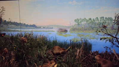
Beaver Meadow wetland exhibit – Rochester Museum of Science
Beginning at the most southern city in Nephite territory,
the fenced cities near the shore of
“the east sea” are:
The city of Moroni - which is explicitly
said to have been “by the east sea ... on the south by the line of
possessions of the Lamanites [what the Nephites called the land of Nephi]”.
(Alma 50:13)
Had the city of Mulek been on the same side of the lake as the city of
Moroni, perhaps it would have been listed first (not last) in order of
conquests from the south. (Alma
51:22-26)
The fact that the land and city of Moroni was “by the east sea” and yet had
“wilderness on the east”, is consistent with the city and land of Moroni
situating on the
southern end of the lake. (Alma
62:34)
The city of Nephihah
- which is said to have been positioned so that it joined both “the borders
of Aaron and Moroni”. (Alma
50:14) It makes sense that the suburbs of all seven coastal towns
were similarly joined, or nearly joined so that the inhabitants could
readily flee a city to one nearby - which is exactly what happened! (Alma
51:24)
The city of Nephihah was on the
eastern side of the “head of Sidon” (headwaters of Buffalo River) across
from the land of Manti. (Alma
56:25;
59:5-6) Therefore the “east sea” had to have been near the
headwaters of Buffalo Creek/River (as is the
Gallagher
Swamp
region). Did an ancient tributary of Sidon once flow from “the east sea”?
The city of Aaron
(Alma
50:14)
The city of Lehi - “which was in the north by the
borders of the seashore [implying
the east sea].” (Alma
50:15)
The city of Morianton - which we know “joined upon
the borders of Lehi; both of which were on the borders by the seashore [implying
the east sea].” (Alma
50:25)
The city of Omner (Alma
51:26)
The city of Gid
- “all of which [the before listed cities] were on the east borders by the
seashore [implying
the east sea; in the context of Moroni being “by the east sea”].” (Alma
51:26-27)
The fenced city of Gid was likely stationed near the northern end
of the lake, so that from there, an invading army from the south, or
missionaries coming from the north could reach the southern
stronghold of Mulek
on the
other side of the lake. (Alma
51:26,
Helaman 5:14-16) Mulek was far enough south (near an extreme
southern end of the lake) that it was considered to be “in the land of
Nephi.” (Alma
53:6) In fact, Mulek may have been a Lamanite stronghold
before is was taken by Nephite forces and renamed. (Alma
50:11)
So how big of a lake would the “the east sea” have
needed to be in order to accommodate a series of seven fortified villages
(what the Bible calls “fenced cities”;
2 Kings 18:13,
2 Chronicles 17:2) along its coast?
To estimate an answer we need to know how big an
Israelite fenced city
was with its surrounding suburb? The
Torah gives us an idea: From
Numbers 35:4-5
we may generously assume 2000 cubits (about 17.5 inches/cubit) to be the
distance along one side of a palisade city, having a suburb perimeter
extending 1000 cubits beyond any wall. The entire distance across a
Nephite city, including its suburbs end-to-end, therefore amounts to only
(4000 cubits)(17.5 inches/cubit)(1 ft/12 inches)/(5,280 ft/mile) ≈ 1.1
miles.
All seven Nephite fortified towns could have hugged
the shore of a lake that was less than 8 miles long - about the size of one
of the
smaller Finger Lakes. This means that from Gid you could walk (or
march) perhaps less than 10 miles to Mulek (stationed
southward in the land of Nephi). It should be clear to students
of the
Book of Mormon that the distance between Bountiful in the north, and
Mulek (land of Nephi border) in the south is not very great - less than a
night’s or a day’s march.
(Alma
52:18-28)
Exaggerated geography
promoters (including
Heartlanders
) - what are you thinking?
Scripture References
18
… they had not kept sufficient guards in the land of Zarahemla;
for they had supposed that the Lamanites durst not come into the heart of
their lands to attack that great city Zarahemla.
(Helaman 1:18)
22 And now when Coriantumr saw
that he was in possession of the city of Zarahemla, and saw that the
Nephites had fled before them, and were slain, and were taken, and were cast
into prison, and that he had obtained the possession of the strongest hold
in all the land, his heart took courage insomuch that he was about to go
forth against all the land.
23 And now he did not tarry in the
land of Zarahemla, but he did march forth with a large
army, even towards the city of
Bountiful; for it was his determination to go
forth and cut his way through with the sword, that he might obtain the
north parts of the land.
24
And, supposing that their greatest strength
was in the center of the land, therefore he did march forth, giving
them no time to assemble themselves together save it were in small bodies;
and in this manner they did fall upon them and cut them down to the earth.
25
But behold, this march of Coriantumr through the center of the land
gave Moronihah great advantage over them, notwithstanding the greatness of
the number of the Nephites who were slain.
26
For behold, Moronihah had supposed that the Lamanites durst not come into
the center of the land, but that they would attack the cities round
about in the borders as they had hitherto done; therefore Moronihah had
caused that their strong armies should maintain those parts round about by
the borders.
27
But behold, the Lamanites were not
frightened according to his desire, but they had come into the center of
the land, and had taken the capital city which was the
city of Zarahemla, and were marching through the most capital
parts of the land, slaying the people with a great slaughter, both men,
women, and children, taking possession of many cities and of many
strongholds.
28
But when Moronihah had discovered this, he immediately sent forth Lehi with
an army round about to head them before they should come to the land Bountiful.
29
And thus he did; and he did head them before they came to the land
Bountiful, and gave unto them battle, insomuch that they
began to retreat back towards the
land Zarahemla.
30 And it came to pass that Moronihah did head them in their retreat, and
did give unto them battle, insomuch that it became an exceedingly bloody
battle; yea, many were slain, and among the number who were slain Coriantumr
was also found.
31
And now, behold, the Lamanites could not retreat either way, neither on the
north, nor on the south, nor on the east, nor on the west, for they were
surrounded on every hand by the Nephites.
(Helaman 1:22 - 31)
21
But Gidgiddoni saith unto them: The Lord forbid; for if we should go up
against them the Lord would deliver us into their hands; therefore we will
prepare ourselves in the center of our lands,
and we will gather all our armies together, and we will not go against them,
but we will wait till they shall come against us; therefore as the Lord
liveth, if we do this he will deliver them into our hands.
22
And it came to pass in the seventeenth year, in the latter end of the year,
the proclamation of Lachoneus had gone forth throughout all the face of the
land, and they had taken their horses, and their chariots, and their cattle,
and all their flocks, and their herds, and their grain, and all their
substance, and did march forth by thousands and by tens of thousands, until
they had all gone forth to the place which had been appointed that they
should gather themselves together, to defend themselves against their
enemies.
23
And the land which was appointed was the
land
of Zarahemla, and the land which
was between the land Zarahemla and the land Bountiful,
yea, to the line which was between the land Bountiful and the land Desolation.
(3 Nephi 3:21 - 23)
32
And now, it was only the distance of a day and a half's journey for a
Nephite, on the line Bountiful and the land
Desolation, from the east to the west sea; and thus the land of Nephi
and the land of Zarahemla were nearly surrounded by water, there being a
small neck of land between the land northward and the land southward.
33
And it came to pass that the Nephites had inhabited
the land Bountiful, even from the east unto the west sea, and thus
the Nephites in their wisdom, with their guards and their armies, had hemmed
in the Lamanites on the south, that thereby they should have no more
possession on the north, that they might not overrun the land northward.
(Alma
22:32 - 33)
8
And the land
of Nephi did
run in a straight course from the east sea to the west.
(Alma 50:8)
11 And thus he cut off all
the strongholds of the Lamanites in the east wilderness, yea, and also on
the west, fortifying the line between the Nephites
and the Lamanites, between
the land of Zarahemla and the land of
Nephi, from the west sea, running by the head of the river Sidon—the
Nephites possessing
all the land northward, yea, even all the land which
was northward of the land Bountiful, according to their pleasure.
13 And it came to pass that the
Nephites began the foundation of a city, and they called the name of the
city Moroni;
and it was by the east sea; and it was on
the south by the line of the possessions of the Lamanites.
(Alma 50:11, 13)
13
And thus he was endeavoring to harass the Nephites, and to draw away a part
of their forces to that part of the land, while he had commanded those whom
he had left to possess the cities which he had taken, that they should also
harass the Nephites on the borders by the east sea,
and should take possession of their lands as much as it was in their power,
according to the power of their armies.
(Alma
52:13)
11
And he also said unto him, I would come unto you, but behold, the Lamanites
are upon us in the borders of the land by the west
sea; and behold, I go against them, therefore I cannot come unto you.
12
Now, the king (Ammoron) had departed out of the land of Zarahemla,
and had made known unto the queen concerning the death of his brother, and
had gathered together a large number of men, and had marched forth against
the Nephites on the borders by the west sea.
13 And thus he was endeavoring to harass the Nephites,
and to draw away a part of their forces to that part of the land, while he
had commanded those whom he had left to possess the cities which he had
taken, that they should also harass the Nephites on the borders by the
east sea, and should take possession of their lands as much as it was in
their power, according to the power of their armies. (Alma
52:11 - 13)
8
And now it came to pass that the armies of the Lamanites,
on the west sea, south, while in the absence
of Moroni on account of some intrigue amongst the Nephites, which caused
dissensions amongst them, had gained some ground over the Nephites, yea,
insomuch that they had obtained possession of a number of their cities
in that part of the land.
(Alma 53:8)
22
And now it came to pass that Helaman did march at the head of his two
thousand stripling soldiers, to the support of the people
in the borders of the land on the south by the west
sea.
(Alma
53:22)
5 And it came to pass that Hagoth,
he being an exceedingly curious man, therefore he went forth and built him
an exceedingly large ship, on the borders of the land Bountiful, by the
land Desolation, and launched it forth into the west sea, by the narrow neck
which led into the land northward.
(Alma 63:5)
5 And in the fifty and seventh year they did come down
against the Nephites to battle, and they did commence the work of death;
yea, insomuch that in the fifty and eighth year of the reign of the judges
they succeeded in obtaining possession of the land of
Zarahemla; yea, and also all the lands, even unto the land which was near
the land Bountiful.
6 And the Nephites and the
armies of Moronihah were
driven even into the land of Bountiful;
7 And there they did fortify
against the Lamanites, from the west sea, even unto the east; it being a
day's journey for a Nephite, on the line which they had fortified and
stationed their armies to defend their north country.
(Helaman 4:5 - 7)
Narrow Neck versus Narrow Pass
Truth Table
|
Scriptural, Geographic Constraints:
|
“narrow neck“:
|
“narrow
pass”:
|
|
By “the west sea”.
|
Yes,
Alma 63:5
|
|
|
Associated with “the place where the sea divides the land.”
|
Yes,
Ether 10:20
|
|
|
Only known to lead “into the land northward.”
|
Yes,
Alma 63:5
|
|
|
Connects both “land northward” and “land southward”.
|
|
Yes,
Alma 50:34;
52:9,
Mormon 2:29;
3:5
|
|
By an unnamed body of water referred to as a “sea”.
|
|
Yes,
Alma 50:34,
Mormon 3:5-8
|
|
Waters of the unnamed “sea, on the west and on the east” of it.
|
|
Yes,
Alma 50:34
|
|
Small enough in width to be described as a geographic “point”.
|
|
Yes,
Alma 52:9
|
The NEAR CUMORAH LITERARY SETTING

Vincent Coon
וִינְסֶנט כּוּן
© Copyright 2015
|